| April 12 • Gooseberry Canyon; Canyonlands National Park |
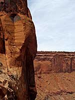
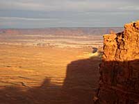 I arrived at Island In The Sky, Canyonlands National Park, Utah at about 7:00 a.m. and went directly to the Green River Overlook for a few photos and then drove to the trail head for Gooseberry Canyon which begins at the same place as the trail to the White Rim Overlook, near the south end of the road. I had a muffin breakfast, made a sandwich and took two photos looking over the cliff before hitting the trail at 8:00. I had expected a steep trail but was kinda surprised how steep it really was. I'm not accustomed to hiking downhill at the beginning of a hike, so this was different. There were lots of switch backs, so the trail wasn't difficult. At the turns in many of the switch backs I shot photos attempting to show just how steep this hill was and how great the view was in the distance. I was thinking all the time that I wouldn't be enjoying this view if I was in a four-wheel-drive vehicle down on the White Rim Road (the other way to get to Gooseberry Canyon). I arrived at Island In The Sky, Canyonlands National Park, Utah at about 7:00 a.m. and went directly to the Green River Overlook for a few photos and then drove to the trail head for Gooseberry Canyon which begins at the same place as the trail to the White Rim Overlook, near the south end of the road. I had a muffin breakfast, made a sandwich and took two photos looking over the cliff before hitting the trail at 8:00. I had expected a steep trail but was kinda surprised how steep it really was. I'm not accustomed to hiking downhill at the beginning of a hike, so this was different. There were lots of switch backs, so the trail wasn't difficult. At the turns in many of the switch backs I shot photos attempting to show just how steep this hill was and how great the view was in the distance. I was thinking all the time that I wouldn't be enjoying this view if I was in a four-wheel-drive vehicle down on the White Rim Road (the other way to get to Gooseberry Canyon).It was pretty cloudy all morning and got really gray by the time I got to the White Rim Road. I expected this would make for flat pictures but I shot lots anyway of Gooseberry Canyon which is right at the end of the trail where both meet the road. There is a camping area nearby and there were still two groups of people hanging out there at 10:00. There were six or eight people in each group and I wondered why they were there so late and not proceeding down the road to explore further. “Full-cooler campers,” I assumed; late risers. 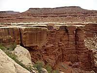 I didn't walk over to talk to the campers but instead worked my way around the rim of the canyon taking more photos and trying to determine the best place to shoot a 360° panorama. The canyon is quite nice with sharp drop offs along its rim. I found a spot where I could walk out on a series of platforms, kind of into the middle of this end of the canyon for my panorama. From there, I went just a little further around the rim to get a shot of those platforms, ate my sandwich and then turned back toward the road. Back at the road 15 minutes later I chatted with two guys who had just come along on mountain bikes about where they were staying, what kind of support they had with them and how long they had been planning the trip. They had made their reservations last July and were traveling with a big group, with two vehicles and lots of bikes. I didn't walk over to talk to the campers but instead worked my way around the rim of the canyon taking more photos and trying to determine the best place to shoot a 360° panorama. The canyon is quite nice with sharp drop offs along its rim. I found a spot where I could walk out on a series of platforms, kind of into the middle of this end of the canyon for my panorama. From there, I went just a little further around the rim to get a shot of those platforms, ate my sandwich and then turned back toward the road. Back at the road 15 minutes later I chatted with two guys who had just come along on mountain bikes about where they were staying, what kind of support they had with them and how long they had been planning the trip. They had made their reservations last July and were traveling with a big group, with two vehicles and lots of bikes.
I had expected the nearby camping area might be set next to some scenic rock formations or something but it was right there on the flats near the end of the canyon. Kind of a dull-looking spot for a camping area, with a pit toilet nearby. I supposed they save the scenic spots, leaving them unspoiled by camping and toilets. By now the campers I saw earlier had left and for the moment, these two bicyclists and myself were the only ones around. Several minutes later, other bikes, men and women passed by, along with their support vehicles. Everyone waved and said hi. For a few minutes all was quiet and I used the pit toilet in preparation for the climb back to my car. As I approached the beginning of the trail some 100 yards from the toilet and camping area, here came another group of bikers and a vehicle and I shot a photo of them coming around the bend. I thought to myself I would like to try to do that someday. |
 The last mile of the trail is just as steep on the way up as it is on the way down and I set a slow but steady pace and drank lots of water. As I was about half way up the side of the canyon wall, I saw the same guy I saw earlier, way below, already starting up the steep part. I guessed he must have made it to the road and the end of Gooseberry Canyon and turned around immediately. I’m not usually a competitive hiker but didn’t really want him to pass me on the way up so I quickened my pace a little. I figured it would be good to have him behind for safety reasons anyway. With the quickened pace, when I got to the car, I found that the climb had gone faster than the descent; only an hour and 45; vs. two hours on the way down. Please click